

Two tropical waves crossed Costa Rica in three days, leaving nearly 500 people in emergency shelters, 862 schools closed and the Caribbean coast, the Northern Zone and Turrialba under an orange alert that still stands this afternoon. If you are in any of those areas, plan around the rain this week rather than waiting for it to pass.
What gets lost in the flood footage is that the other half is having its driest stretch of the year. Guanacaste carries no alert at all. Same country, same three days, opposite extremes, and one pattern out in the Pacific Ocean driving both of them.
The rain is not the real problem anymore
Soil in the Caribbean river basins is now between 90% and 100% saturated. In the southern Pacific it is above 85%.That figure matters more than any rainfall total. Saturated ground behaves like a full sponge, so whatever falls next runs straight off the surface into rivers and streets instead of soaking in.
It also means a modest shower can now do what a heavy one did a week ago. Rivers rise faster, hillsides give way more easily, and storm drains in town centers back up within minutes rather than hours.
Two tropical waves, back to back
Tropical wave No. 32 crossed Costa Rica on Saturday and Sunday. No. 33 followed on Monday, arriving while the Intertropical Convergence Zone sat over and trade winds pushed moisture in off the Caribbean Sea. Over the weekend, six-hour rainfall in Cahuita, Limón and Talamanca reached 70 to 110 millimeters (2.8 to 4.3 inches).
The Instituto Meteorológico Nacional forecast another 20 to 50 millimeters (0.8 to 2 inches) through Monday, with local peaks above 100 millimeters (3.9 inches) in the mountains. The damage followed quickly. Turrialba mayor Carlos Hidalgo Flores reported seven homes destroyed outright in his canton and others partially damaged, including one house flattened by a falling tree in Verbena Norte.
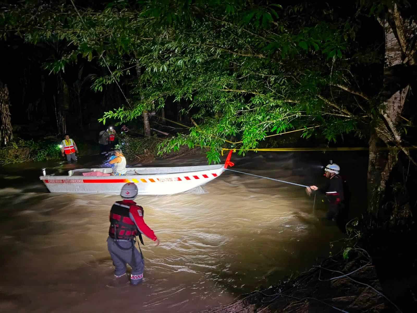
Red Cross crews pulled more than 160 people out of their homes across Sarapiquí and the Limón region, some by boat, many with pets and elderly relatives in tow. Roads took the worst of it. Route 32, the main link between San José and Limón, closed and reopened over the weekend. The bridge over the Río Chirripó on Route 4 in Sarapiquí stayed shut for close to 24 hours before inspectors cleared it Monday morning and found no structural damage.
By late morning, every road the rain had closed was open again. That is the recovery pattern worth understanding here, because it repeats: these routes shut fast, then reopen within a day once crews clear the material.
The other half of the country is running dry
Here is the part that makes this stretch genuinely unusual. While the Caribbean floods, the Pacific is in the middle of its driest spell of the year. A strong El Niño is in place, and forecasters expect it to hold through the rest of 2026, possibly strengthening further before it fades during 2027. El Niño tends to suppress rainfall on Costa Rica’s Pacific side and in the Central Valley while leaving the Caribbean wetter than normal.
Layered on top of that is the canícula, the mid-season dry spell that interrupts the Pacific rains in July and August. This year it arrived longer and more intense than usual. Fourteen weather stations set daily heat records on Aug. 11, the most in a single day so far this year, with Sardinal in Carrillo reaching 37.8 C (100 F). Every province recorded at least one except Limón.
So one strong El Niño is producing a flood emergency on one coast and a drought watch on the other, at the same time, in a country you can drive across in five hours.
What the next four weeks look like
The national outlook going from Aug. 17 through Sept. 13 keeps that split in place for a while yet. Through Aug. 23, the Caribbean stays wet, with weekly totals of 70 to 185 millimeters (2.8 to 7.3 inches) in the northern Caribbean and 35 to 95 millimeters (1.4 to 3.7 inches) in the south. The Northern Zone runs close to normal at 40 to 145 millimeters (1.6 to 5.7 inches). The entire Pacific stays very dry.
The following week, Aug. 24 to 30, looks much the same, with the canícula ending but El Niño keeping the central and northern Pacific in deficit. The turn comes around Aug. 31. From then through mid-September, the Caribbean and the Northern Zone are expected to settle back to normal levels for the season, while the Pacific, the Central Valley and the western Northern Zone stay dry.
Forecasters put the odds of another extreme event over the next two weeks at roughly 25% and do not currently expect a major system to strike directly in that window. That is a projection rather than a promise, and confidence drops sharply for the second week of September.
If you have travel booked this week
The Caribbean coast and the Northern Zone are the areas to watch. Puerto Viejo, Cahuita, Tortuguero, Sarapiquí, Guápiles and the Turrialba area have all seen road closures, river flooding or both in the last three days. Check road conditions before you set out, not after. Route 32 between San José and Limón and Route 4 through Sarapiquí are the two corridors most likely to shut on short notice, because both run below slopes that shed material once the ground is this wet.
Never drive into standing water on a flooded road. Half a meter (roughly 20 inches) of moving water is enough to float a vehicle, and you cannot see whether the road surface underneath is still there. If your plans are flexible, the Pacific is the obvious alternative right now. Guanacaste, the Nicoya Peninsula and the central Pacific are dry, sunny and running well below normal rainfall.
Call 911 if you need rescue or evacuation, and call early rather than waiting until water is at the door. The rain will ease. The open question is how fast the ground drains, because until saturation drops, every wave that crosses will land harder than the raw numbers suggest.





