

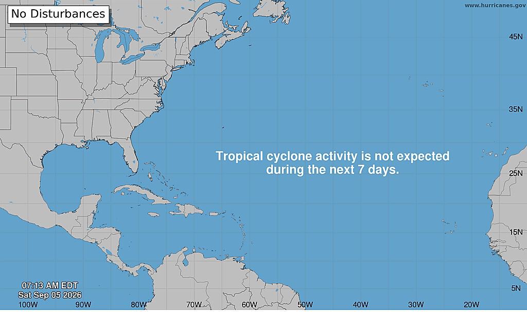
The Atlantic has reached the second week of September without a single hurricane. That has not happened in a very long time, and forecasters do not expect it to change soon. The National Hurricane Center’s outlook says no tropical cyclone is expected to form anywhere in the Atlantic, the Caribbean Sea or the Gulf over the next seven days. That takes the basin past the middle of the month with nothing on the horizon.
Five named storms had formed by the start of September — Arthur, Bertha, Cesar, Dolly and Edouard. None reached sustained winds of 119 km/h (74 mph), which is the line a storm has to cross to be called a hurricane. If none does so before September 12, this becomes the longest wait for a first Atlantic hurricane since satellites began tracking them.
For a basin that normally does most of its work between mid-September and October, that is a strange place to be standing.
The reason is sitting in the Pacific
El Niño is a periodic warming of the surface waters in the central and eastern Pacific. It shifts wind patterns across a huge stretch of the planet, and one of its most reliable effects is to make the Atlantic hostile to hurricanes. It strengthens the high-altitude winds that shear developing storms apart before they can organise.
Forecasters saw this coming. NOAA’s seasonal outlook in May put the odds of a below-normal Atlantic season at 55 percent, against 35 percent for near-normal and just 10 percent for above-normal, and pointed to El Niño as the reason. Colorado State University’s forecast called for 13 named storms, six hurricanes and two major ones — a slightly quiet year.
What makes El Niño worth understanding is that it does not simply switch storms off. It moves them. While the Atlantic has produced no hurricanes at all, the eastern Pacific has been running three simultaneously. Karina, Lowell and Marie were all active as of Friday, spread between the waters east of Hawaii and the seas southwest of Baja California.
Forecasters are also watching a low-pressure area that may develop well off southwestern Mexico early next week, with a roughly even chance of becoming a tropical depression by midweek. All of it is far from Costa Rica and none of it is forecast to come closer. That is the same phenomenon producing both results. The conditions that tear Atlantic storms apart are the conditions that help Pacific ones grow.
The same pattern is showing up in the forecast here
Costa Rica is feeling El Niño in a different form, through rainfall rather than storms. The National Meteorological Institute’s outlook for late August into September projects dry conditions across the whole Pacific slope, the Central Valley and the western Northern Zone, with the Caribbean returning to something closer to normal for the season.
That rainfall deficit is expected to hold through the first half of September, which is ordinarily one of the wetter stretches of the year on the Pacific side. The Institute’s climate unit has been flagging this for months. Its early warning system for the El Niño cycle moved from watch to warning earlier in the year, meaning the uncertainty about whether the phenomenon would arrive had effectively disappeared.
Projections at the time pointed to temperatures up to 2°C (3.6°F) above normal and rainfall reductions of as much as 50 percent in some regions through the second half of 2026. NOAA has put the odds of the pattern persisting into early 2027 at 96 percent.
What this actually means
If you have plans in the coming week, the practical answer is straightforward. Nothing tropical is approaching, and the Pacific side is drier than a September usually is. The longer answer needs more care. A quiet basin is not a finished season. The Atlantic season runs to November 30, and Costa Rica’s most serious tropical event in living memory arrived in November.
Conditions that suppress storms for weeks can relax, and forecasters have been explicit that short-term patterns can open windows for a storm to strengthen quickly. A seasonal forecast counts storms across an entire ocean; it cannot tell you where any of them will go. The Caribbean slope is also on a different pattern from the Pacific. It is not in the rainfall deficit, and it remains the part of the country most exposed to the moisture that tropical systems drag south even when they never come near land.
And a dry green season is not uncomplicated good news. Reservoirs fill in these months, and the water stored now is what runs the taps and the turbines later. A rainfall deficit in September is a question that gets asked again in March. For the moment, though, the sky is mostly empty, and that is worth something.





