
LOS CHILES, Alajuela — If you ask random strangers in northern Alajuela province where la trocha is, they know exactly what you’re talking about. They give explicit directions, because there aren’t a lot of signs out there, and it’s easy to get lost. Once you leave the highway, the landscape is a checkerboard of pineapple fields, fences, shanties and trees. Villages consist of a few clustered houses and a soda. Trucks crawl slowly through a labyrinth of dusty byways.
But the closer you get to la trocha, the less locals know which trocha you’re talking about. After all, the word just means “path” or “dirt road,” and as you inch closer to the Nicaraguan border, every road is basically a trocha.
This is one of the surprising truths about the 1856 Juan Rafael Mora Porras roadway, the 160-kilometer dirt and gravel road that parallels the border with Nicaragua going east from Los Chiles, a town that sits roughly at the middle point along the two countries’ east-west border (1856 is the year Costa Rica defeated filibuster William Walker, under the leadership of President Juan Rafael Mora).
From its western end, the road isn’t easy to find. In theory, a traveler should only have to drive north on Route 35 and take a right at Los Chiles. But the road doesn’t exactly start in Los Chiles. Rather, it’s embedded deep in the countryside, beyond rolling pineapple fields. Once you do find the road, you can’t go very far before it becomes impassable.
If the road were complete, you could drive all the way to Delta Costa Rica, a patch of land where the Colorado and San Juan rivers merge. Yet the actual geography is far more confusing – as is every other aspect of la trocha.
Since its inception, Route 1856 has been a political nightmare. When the Nicaraguan government started to build a canal through the marshy flatlands of Isla Portillos in 2010, the Costa Rican government called the construction — and the presence in the area of Nicaraguan troops — an “invasion” and filed suit against its neighbor in the International Court of Justice in The Hague.
Then, in 2011, President Laura Chinchilla’s administration came up with a passive-aggressive counter-attack: it declared a national emergency that it said required the government to build a roadway paralleling the border in order to protect national sovereignty. The emergency decree allowed the government to forego the normal environmental review process.
The road project was immediately attacked — in Costa Rica and Nicaragua — and was soon mired in allegations of corruption. In 2012, Costa Rican daily La Nación reported that five businesses hired for the project did not own the necessary equipment and had no experience as state contractors. The $5.6 million debacle forced Public Works and Transport Minister Francisco Jiménez to resign and did serious damage to the National Roadway Council’s (CONAVI) reputation.
Meanwhile, the Nicaraguan government accused Costa Rica of filling up the San Juan River with construction runoff and filed its own suit before the International Court of Justice in December 2011. The dueling lawsuits were joined into one case in 2013 and both countries gave their final oral arguments in the dispute last month. A ruling could come before the end of this year.
Recommended: Costa Rica, Nicaragua enter final hearings at The Hague in border dispute
Costa Rican President Luis Guillermo Solís has publicly promised to clean up his predecessor’s trocha mess, but how that happens is unclear. Transport Ministry spokesman Roberto López Alpízar said design plans were still pending for the route’s five sections.
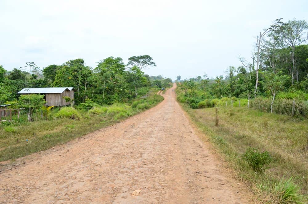
For all its controversy, the road itself has largely been a mystery to the general public because of its remoteness. Near Los Chiles, the road looks unremarkable, just a yellow stretch of gravel cutting straight toward the horizon, and its significance isn’t visible to the naked eye. But here, if you cross the road, you step onto Nicaraguan soil. There is no fence, no sign, and no soldier patrolling the route. The ramshackle houses look identical on both sides, as do the ragged residents.
Costa Rican farmers use the road to transport pineapples in large trucks, and scattered locals use the road to walk or drive home. Nicaraguans are forbidden to drive on the trocha, but schoolchildren heading home frequently zigzag from one country to the other without a second thought.
Here the San Juan River is nowhere in sight. The road doesn’t begin to closely parallel the river until further east. The region feels isolated, and it is. A 2009 Hague court document notes that, by Costa Rica’s own count, only about 450 people lived along the 140 kilometers of Route 1856 that stretches along the San Juan River.
On this end of the road, the population seems difficult to accurately estimate because many of the families here are longtime squatters.
“We knew they were going to move us when they started to build the road,” one local said. “So we moved farther away from the road. But we know that they will probably move us from here, too. We don’t own the land.”
Makeshift settlements punctuate the area’s peculiar landscape. Entire cottages have been fashioned from stray planks and plastic tarp. In this gray area between the two quarreling nations, quiet poverty is the norm.
From its western starting point, you only have to travel a couple of kilometers before the road abruptly ends, at least for motor vehicles: Where a small bridge once forded a babbling brook, now there is only a pile of rubble. The makeshift bridge collapsed some time ago, and no one has ever replaced it. The distance isn’t great; walkers can easily hopscotch across the debris. Yet for a car or truck, it might as well be the Grand Canyon.
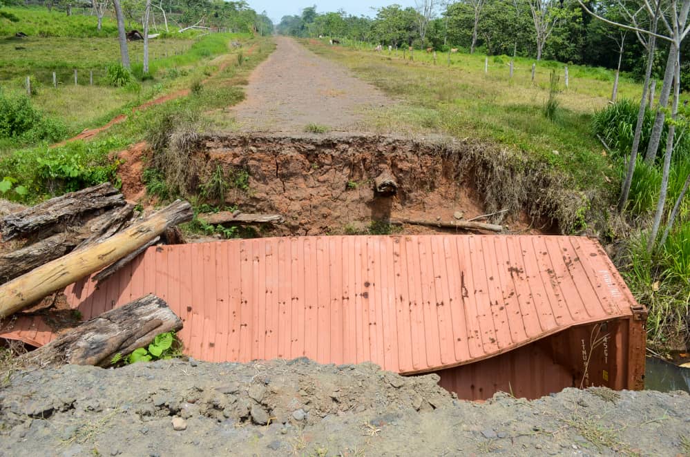
In a way, this collapsed bridge represents the trocha in its entirety, a seemingly straightforward project that is, for now, nearly useless. Looking at the road in person fails to bring its potential into focus. But one day, Costa Rican citizens and visitors could be able to drive the length of the San Juan River, until it meets the Colorado. The road might help the local economy, raising families out of destitution. The road could connect to the brand new immigration post at Las Tablillas, expediting travel to hard-to-reach communities and building commercial ties between the bickering Central American neighbors.
But until then, the trocha is just a road to nowhere.


